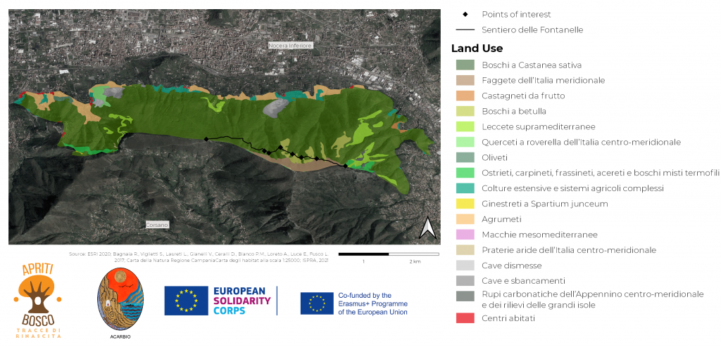
Con questa mappa puoi dare un’occhiata di come il terreno viene utilizzato nel progetto “Apriti Bosco”.
La parte chiaramente più grande della zona è coperta da una foresta di castanea sativa .
Sempre nella famiglia delle piante di castagno si trovano i castagneti da frutto. Gli alberi di castagno sono largamente diffusi nella regione dei Monti Lattari.
Un’altra pianta molto importante nell’area di progetto è la betulla.
Ai confini del progetto si possono scoprire centri abitati. Vicino a questi insediamenti si accumula la presenza di argumeti .
Oltre che dalle piante anche alcune cave e rupi ricoprono il suolo nell’area di progetto.
On this map you can have a look on how the soil is being used in the project area of “Apriti bosco”.
The clearly biggest part of the area is covered with forest of the castanea sativa (european chestnut).
Also in the family of the chestnut plants there is the castagneti da frutto. Chestnut trees are wide-spread in the region of Monti Lattari.
An other important plant in the project area is the betulla (birch).
At the borders of the project are you can discover centri abitati (settlement areas). Near this settlements the occurrance of argumeti (citrus fruits) accumulates.
Apart from plants also some cave (holes) and rupi (rocks) cover the soil in the project area.